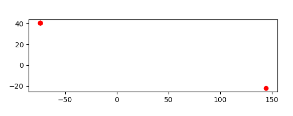
geopandas supports geocoding (i.e., converting place names to location on Earth) through geopy, an optional dependency of geopandas. The following example shows how to get the locations of boroughs in New York City, and plots those locations along with the detailed borough boundary file included within geopandas.
geopandas 通过 geopy 支持地理编码(即,将地名转换为地球上的位置),这是 geopandas 的可选依赖项。以下示例展示了如何获取纽约市行政区的位置,并绘制这些位置以及 geopandas 中包含的详细行政区边界文件。
In [1]: boros = geopandas.read_file(geopandas.datasets.get_path("nybb"))

In [2]: boros.BoroName
Out[2]:
0    Staten Island
1           Queens
2         Brooklyn
3        Manhattan
4            Bronx
Name: BoroName, dtype: object

In [3]: boro_locations = geopandas.tools.geocode(boros.BoroName)

In [4]: boro_locations
Out[4]:
                              geometry                                            address
0   POINT (-74.149604800 40.583455700)  Staten Island, City of New York, New York, Uni...
1  POINT (144.584490300 -22.164678200)                              Queensland, Australia
2   POINT (-73.949721100 40.652600600)  Brooklyn, City of New York, New York, United S...
3   POINT (-73.959893900 40.789623900)  Manhattan, City of New York, New York, United ...
4   POINT (-73.878593700 40.846650800)  The Bronx, City of New York, New York, United ...

In [5]: import matplotlib.pyplot as plt

In [6]: fig, ax = plt.subplots()

In [7]: boros.to_crs("EPSG:4326").plot(ax=ax, color="white", edgecolor="black");

In [8]: boro_locations.plot(ax=ax, color="red");
By default, the geocode() function uses the Photon geocoding API. But a different geocoding service can be specified with the provider keyword.
默认情况下,geocode() 函数使用 Photon 地理编码 API。但是可以使用 provider 关键字指定不同的地理编码服务。
The argument to provider can either be a string referencing geocoding services, such as 'google', 'bing', 'yahoo', and 'openmapquest', or an instance of a Geocoder from geopy. See geopy.geocoders.SERVICE_TO_GEOCODER for the full list. For many providers, parameters such as API keys need to be passed as **kwargs in the geocode() call.
provider 的参数可以是引用地理编码服务的字符串,例如“google”、“bing”、“yahoo”和“openmapquest”,也可以是来自 geopy 的 Geocoder 实例。有关完整列表,请参阅 geopy.geocoders.SERVICE_TO_GEOCODER。对于许多提供程序,API 密钥等参数需要在 geocode() 调用中作为 **kwargs 传递。
For example, to use the OpenStreetMap Nominatim geocoder, you need to specify a user agent:
例如,要使用 OpenStreetMap Nominatim 地理编码器,需要指定一个用户代理:
geopandas.tools.geocode(boros.BoroName, provider='nominatim', user_agent="my-application")Attention:
Please consult the Terms of Service for the chosen provider. The example above uses 'photon' (the default), which expects fair usage – extensive usage will be throttled. (Photon’s Terms of Use).
请查阅所选供应商的服务条款。上面的例子使用 “Photon”(默认),它期望合理使用,大量使用将会被限制。(Photon的使用条款)。
